I have completed the individual page for the Hulverston tollhouse.
I managed to find a site about the history of the local area and linked it from the page.
The Newport tollhouse is next
British Tollhouses
I used to live in a tollhouse. Every time I see a tollhouse I take a picture of it. This blog records those pictures and maybe some extra information if I know it. Individual pages for all tollhouses I have details for can be found at https://sites.google.com/site/britishtollhouseswiki/
Wednesday, 23 May 2012
Monday, 21 May 2012
Isle of Wight tollhouse page
I have made the county page for the Isle of Wight at my site, here. One of the tollhouses is a bit speculative as it is a bit modern but looks like it might be the place you are meant to pay for the chain ferry between the Coweses.
Individual pages for each tollhouse coming soon.
Individual pages for each tollhouse coming soon.
Monday, 7 May 2012
Collecting Isle of Wight tollhouses
We spent the weekend on the Isle of Wight, mostly being wet and cold but also collecting as many of the island's tollhouses as we could find.
The map below shows what we managed to do.
Green dotted pins are tollhouses in the national database that we managed to photograph. The undotted green pin is a building that I believe is a toll house and photographed, but it is not in the national database. The red pin is a possible tollhouse, not in the database, but we didn't manage to stop and photograph it (streetview can be used to see it). The yellow pins are the two tollhouses we didn't manage to get to. The Yarmouth one I am not sure which building at the junction is the tollhouse, the St Lawrence one we just didn't manage to get to.
All the photos will be posted online over the next few days.
View Isle of Wight tollhouses in a larger map
Labels:
Isle of Wight,
tollhouse,
UK
Wednesday, 25 April 2012
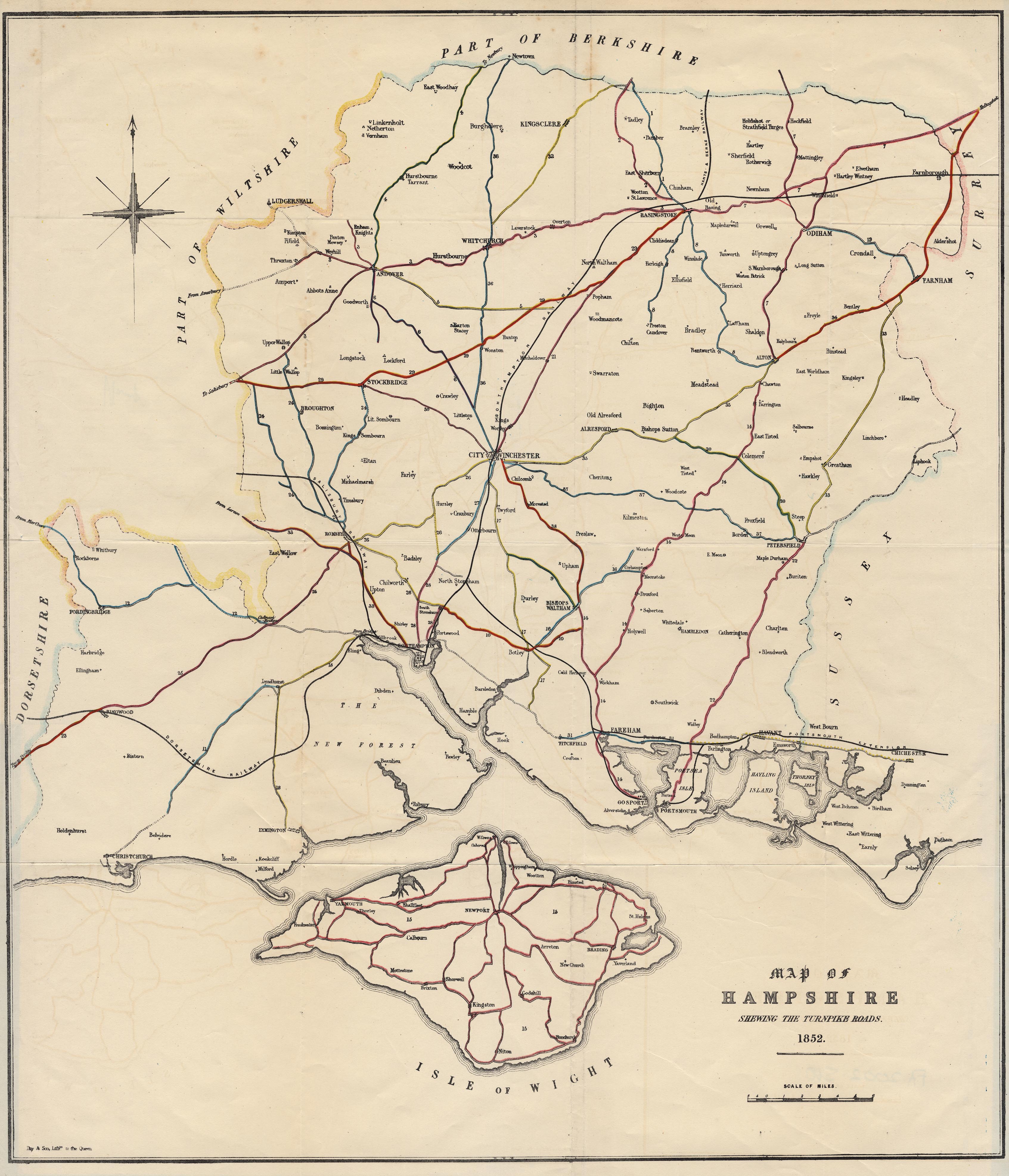
Hampshire turnpike information
I have found a very informative page hosted by the University of Portsmouth here. The page contains many extracts from a report on the turnpikes of Hampshire submitted to parliament in 1852 by Sir George Grey.
Of particular interest is the attached map of the Hampshire turnpike network. There doesn't seem to be any mention of the Basingstoke to Reading road though, the one I used to live alongside.
I will have a go at using this map to produce a set of routes on GoogleEarth showing how the old turnpikes relate to the modern road network. This may reveal the locations of some of the lost tollhouses in the county.
The original document is in the Bodleian Library.
Of particular interest is the attached map of the Hampshire turnpike network. There doesn't seem to be any mention of the Basingstoke to Reading road though, the one I used to live alongside.
The original document is in the Bodleian Library.
Saturday, 21 April 2012
Final Tewkesbury tollhouse
I have completed the page for the Mythe tollhouses, Tewkesbury. The tollhouse and tollbooth stand at the eastern end of a bridge over the river Severn designed by Thomas Telford.
Labels:
Gloucestershire,
tollhouse,
UK
Tuesday, 17 April 2012
Ledbury tollhouse pages
I have added a page for each of the tollhouses in Ledbury that I photographed over the Easter weekend. I have also added a page of links to information about the Leominster & Ledbury Turnpike Trust.
The home page of my tollhouse website can be found here.
The home page of my tollhouse website can be found here.
Labels:
Herefordshire,
tollhouse,
UK
Monday, 16 April 2012
2nd Tewkesbury tollhouse
I have added a page for the second tollhouse in Tewkesbury here. This is a similar looking building to the Ashchurch gate tollhouse.
View Larger Map
View Larger Map
Labels:
Gloucestershire,
tollhouse,
UK
Subscribe to:
Posts (Atom)


